Joint Typhoon Warning Center (JTWC) was in the spotlight earlier this month as the first west Pacific super typhoon of the year, 12W (Hinnamnor) brought wide ranging impacts to the Department of Defense and other U.S. Government agencies operating throughout the region, September 1
st.
After a slow start to the 2022 western north Pacific (WPAC) tropical cyclone (TC) season due to continuing La Niña conditions, Hinnamnor formed late on the 28
th of August east of Iwo To, and rapidly developed into a typhoon over the course of the day.
As the system tracked westward with the island of Okinawa in its crosshairs, continued intensification allowed Hinnamnor to quickly reach the super typhoon designation. With an estimated peak intensity of 140 knots, 12W become the strongest TC on the planet so far this year, based on preliminary data.
JTWC’s consistent and accurate forecast allowed operational commanders at Okinawa to continue operations and avoid a restrictive Tropical Cyclone Condition of Readiness (TCCOR) setting.

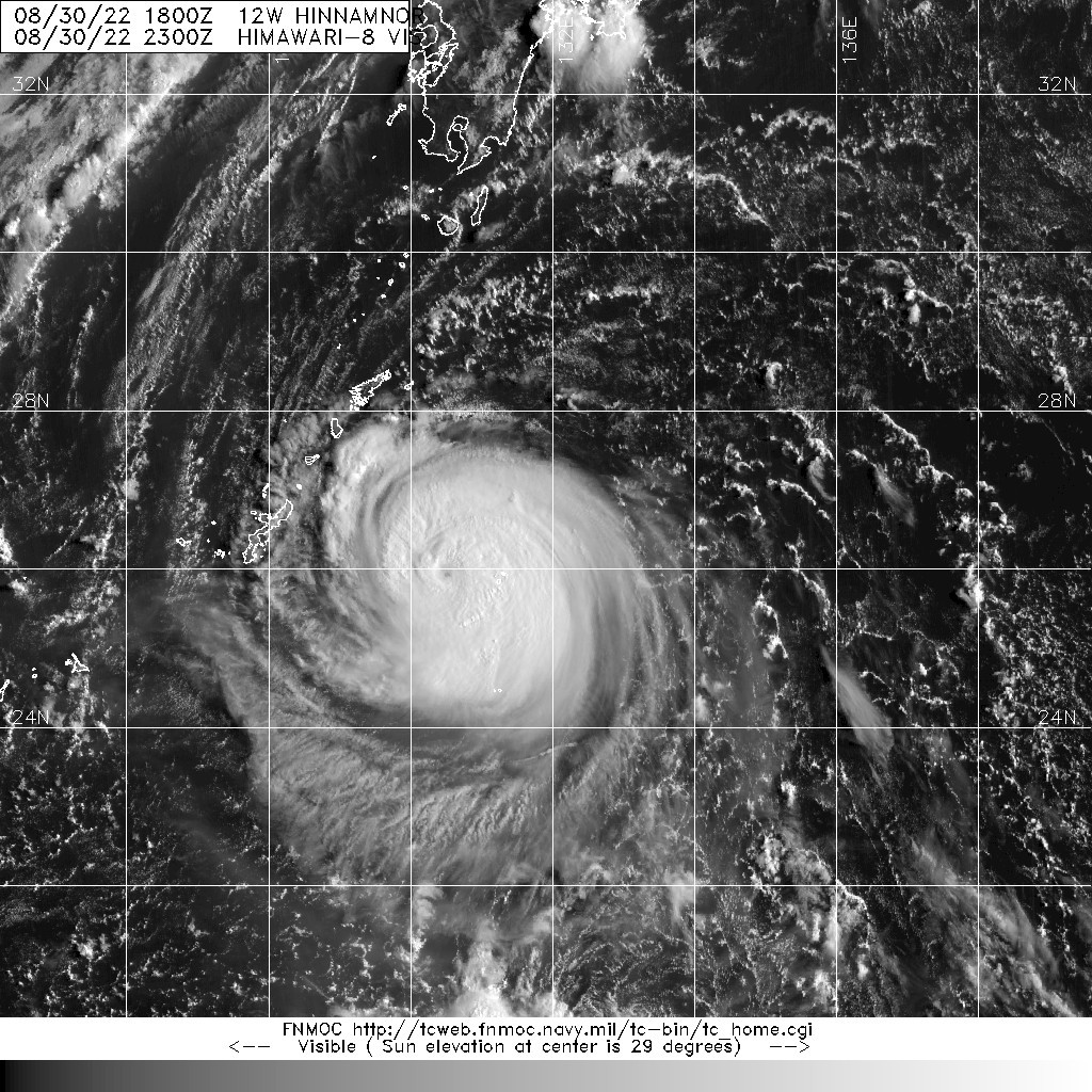
CAPTION: Satellite Himawari-8 visible image of 12W as it approached Okinawa on Aug 30, 2022, just before making a sharp turn towards the southwest and away from making landfall on Okinawa. (Courtesy FNMOC)
As 12W rapidly intensified, many models were predicting Hinammnor had the potential to be the strongest TC to pass near Okinawa since Chaba in 2016, creating high-interest in the event. Fortunately, two days before the expected passage, JTWC forecasts locked in on a track that would take 12W to the southwest just prior to reaching the island.
Indeed, the storm made the sharp turn as forecast, with the center of the system missing the island by only 85 miles. A relatively new tool utilized at JTWC called synthetic aperture radar (SAR), a satellite sensor capable of providing extremely detailed estimates of super typhoon winds from space, provided evidence that Hinnamnor’s destructive wind field at this time was extremely compact, further minimizing the potential risk to Okinawa.
After moving past Okinawa, an even more complex and concerning scenario began to evolve. On September 1
st, JTWC issued a forecast calling for Hinnamnor to slow to a crawl south of the Ryukyu island chain, and begin to weaken due to increasingly cooler ocean temperatures, before making a sharp turn to the north towards the Korean Peninsula.
According to Mr. Brian Howell, JTWC Typhoon Duty Officer, “Such motion is atypical in this region, where TCs typically either move west or recurve back to the north”. At the same time, the wind field was forecast to dramatically grow in size, increasing the extent of dangerous winds. The Navy’s COAMPS-TC weather prediction ensemble, another unique capability used in operations at JTWC, was signaling an extremely high probability for redevelopment of a very strong typhoon.
Three days later, with warmer waters in its path providing fuel for a second round of intensification, Hinnamnor once again crossed the 100 kt threshold as it passed nearly 200 miles to the west of Okinawa, only this time the much larger wind field brought gale force winds to parts of Okinawa.

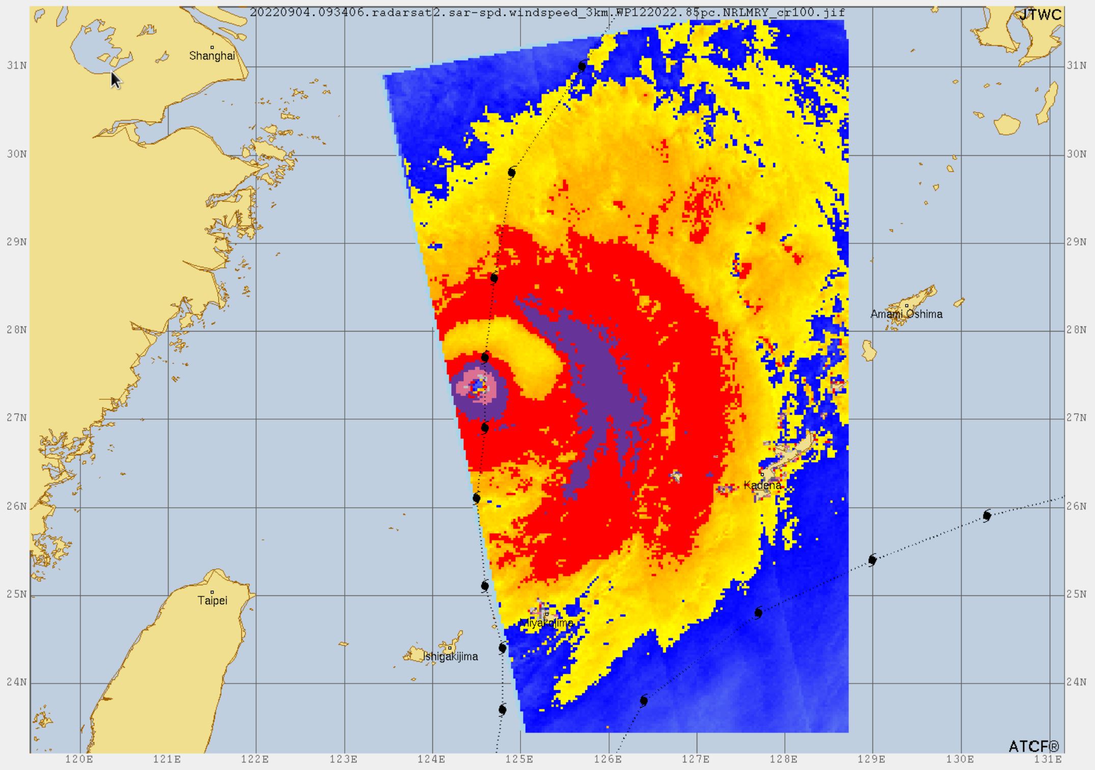
CAPTION: Synthetic aperture radar (SAR) image from Sep 3, 2022, as 12W passed west of Okinawa. The typhoon’s wind field had grown large enough that Okinawa received gale-force winds (in yellow) a second time. (Courtesy NRL)
With each new forecast, JTWC track predictions continued to zero in on the South Korean coastline. Projected to be one of the strongest tropical cyclones to ever strike the Korean Peninsula, Hinnamnor made landfall within 40 nm of the location predicted five days earlier.
A wind gust of 84 knots was recorded on Maejuk-Ri island to the southwest as the eye of the system passed over the region, and another SAR pass shortly thereafter also corroborated forecasts that had consistently called for maximum winds between 80 to 100 knots at landfall. Fortunately, despite the large wind field, the most intense peak winds were confined to a very small area.
Once again, accurate TC predictions enabled decision makers such as Commander Seventh Fleet, Commander US Forces Korea, 18
th Wing and subordinate units to take protective actions well in advance of the storm, thereby minimizing damage to high-value military assets.
Naval Forces Korea Meteorology Officer, LT Williams Griffin shared, “JTWC prognostic reasoning messages have been most excellent reading this storm, and have really enriched our Joint meteorological conversations here in Korea.” Decision-makers across the fleet relied heavily on information provided by JTWC.
According to CDR Christopher Tuggle, Commanding Officer of the Naval Oceanography Antisubmarine Warfare Center in Yokosuka Japan, “The consistency and accuracy [of JTWC warnings] really helped my team nail forecast for Commander, Fleet Activities Sasebo (Japan). We had the max winds nailed 96 hours prior to the closest point of approach!”
The significance of forecasts was best captured by the Pacific Fleet Oceanographer, CAPT Ken Wallace who said, “For most of the year, the daily forecast products of the Joint Typhoon Warning Center garner the attention of Navy leadership across the Pacific and Indian Oceans.
Super Typhoon 12W was a long lived, very powerful storm in a complex atmospheric steering environment and the men and women of JTWC did a masterful job with their track and intensity forecasts. For a very small command, JTWC’s impact on Fleet operations is enormous and their superb forecasting track record is second to none.”

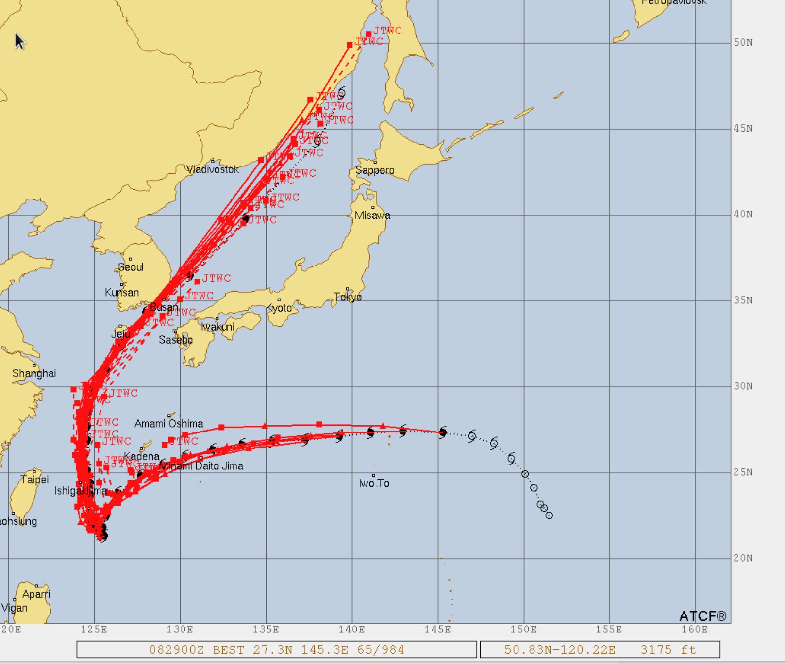
CAPTION: All of JTWC’s 5-day forecast tracks (red lines) for Typhoon 12W (Hinnamnor) compared to actual track (black). JTWC’s forecast tracks were incredibly accurate throughout the duration of the typhoon.
In addition to its US Government customers, Super Typhoon Hinnamnor’s unusual track saw high public interest throughout the region. The JTWC public website, which houses its suite of public products and forecasts, recorded over 2.1 million hits during the course of this storm.
Global press interest was also high, from such sources as the Washington Post “Weather Gang” team, which spotlighted JTWC’s forecasting efforts and the potential for major impacts in Korea. (
https://www.washingtonpost.com/climate-environment/2022/09/01/super-typhoon-hinnamnor-japan-korea/)
With the western north Pacific TC season now in full swing, JTWC and its partners will have their hands full. In a typical year, this part of the world receives approximately 30 tropical cyclones, sixteen of them reaching typhoon strength.
“JTWC’s military and civilian professionals are standing the watch 24/7 to enable effective and efficient fleet and joint force operations through world class TC forecasts, warnings, and decision support to U.S. assets in the Pacific and Indian Oceans. I’m proud of the team for their work on Super Typhoon Hinnamnor and every storm we track!” – Commander Dominic DiMaggio, Commanding Officer of the Joint Typhoon Warning Center.
JTWC is jointly staffed by U.S. Navy and Air Force personnel and falls under the operational control of Commander, Task Group 80.7/Commander, Naval Meteorology and Oceanography Command under Fleet Weather Center San Diego. U.S. Air Force personnel are administratively assigned to the 17th Operational Weather Squadron (OWS), a subordinate squadron of the 1st Weather Group and the 557th Weather Wing.
Joint Typhoon Warning Center’s mission is to enable effective Fleet and Joint Force planning and operations through tropical cyclone (TC) forecasts, warnings, and environmental decision support to U.S. assets in the Pacific and Indian Oceans as established by Commander, U.S. Indo-Pacific Command.
U.S. Naval Meteorology and Oceanography Command directs and oversees more than 2,500 globally-distributed military and civilian personnel who collect, process and exploit environmental information to assist Fleet and Joint Commanders in all warfare areas to make better decisions, based on assured environmental information, faster than the adversary.
For more information about JTWC:
https://www.metoc.navy.mil/jtwc/jtwc.html
Follow Naval Oceanography on Facebook and Instagram (@NavalOceanography), Twitter (@NavyOceans) and LinkedIn.